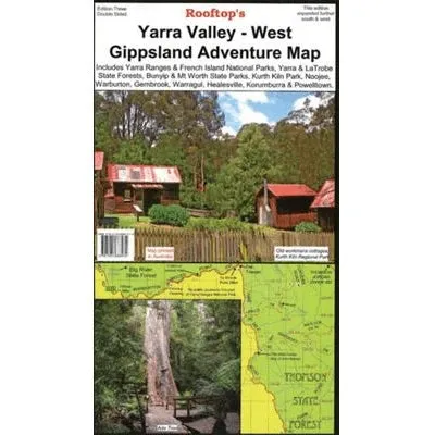
Yarra Valley - West Gippsland Adventure Map – 3rd Edition
Prepare for thrilling outdoor adventures with the Rooftop Maps Yarra Valley - West Gippsland Adventure Map. Designed specifically for motorbiking, bush camping, and four-wheel driving, this double-sided map is the ultimate companion for exploring the stunning natural landscapes of Yarra Valley and West Gippsland.
Features
- Detailed 4WD tracks for off-road adventures
- Highlighted national parks, including Yarra Ranges, Bunyip, and Mt Worth
- Campsites and bush camping areas
- GPS-surveyed roads and tracks for precise navigation
- Durable waterproof paper for rugged outdoor use
Key Specifications
- Edition: 3rd
- Publication Date: 01/10/12
- Scale: 1:100,000
- Folded Size (WxHxD): 140mm x 255mm x 4mm
- Flat Size (WxH): 700mm x 1000mm
- Weight: 0.09kgs
One side of the map features prominent destinations such as Yarra Ranges National Park, Bunyip and Mt Worth State Parks, Kurth Kiln Park, and the vast Yarra, La Trobe, and Toolangi State Forests. Key towns like Healesville, Warburton, Marysville, Gembrook, and Noojee are clearly marked, providing a complete picture of the region. The reverse side offers even more detail for the area between Gembrook and Noojee, ensuring you have all the information needed for an unforgettable adventure.
About the Publisher:
Rooftop Maps are renowned for their precision, reliability, and focus on outdoor exploration. Designed for durability and usability, their maps are the trusted choice for adventurers seeking to navigate Australia’s breathtaking landscapes with confidence.


 Plus Size Snakeskin Pattern Ankle Strap Plush Stilettos")


